

A coastal storm will bring “significant impacts” in the way of high winds and “moderate to major overwash” from the state line to Cape Hatteras, and soundside flooding in some southern locations on the Outer Banks this weekend.
“Conditions will deteriorate today, with very strong winds, significant coastal flooding and ocean overwash, and dangerous marine conditions expected this weekend,” the National Weather Service Newport/Morehead City forecast office wrote in its Saturday morning update.
“Coastal Flood Watches were upgraded to Warnings overnight, and Storm Warnings were issued for storm force winds on the coastal waters and Pamlico Sound,” according to the briefing. “The rainfall forecast has trended down a bit as well, with the heaviest rainfall now expected to remain just offshore.”
“Now is the time to take action necessary to protect flood-prone property especially at ocean and sound front locations,” said Dare County Emergency Management Director Drew Pearson. “If travel is required, do not drive around barricades or through water of unknown depth.”
“Ocean conditions are unsafe swimming and surfing. High surf will lead to beach erosion making beach activities unsafe,” Pearson said.”
An area of low pressure that formed in the Gulf of Mexico and crossed Florida will move up the Gulf Stream through Monday before heading towards Bermuda.
The pressure gradient between high pressure of the mid-Atlantic that was already producing north-northeast winds and the coastal storm will create even stronger winds, especially on Sunday and Sunday night.
A number of local events have had their schedules altered or postponed due to the forecast, including the Outer Banks Half Marathon and the Currituck Bulls & BBQ rodeo.
Dare County Emergency Management issued a statement advising about the situation expected for Saturday night through Monday:
Residents, visitors and property owners — especially those in oceanfront areas and places prone to soundside flooding — are advised to take precautions now to protect property.
Outdoor furnishings, trash cans and any loose items should be properly secured.
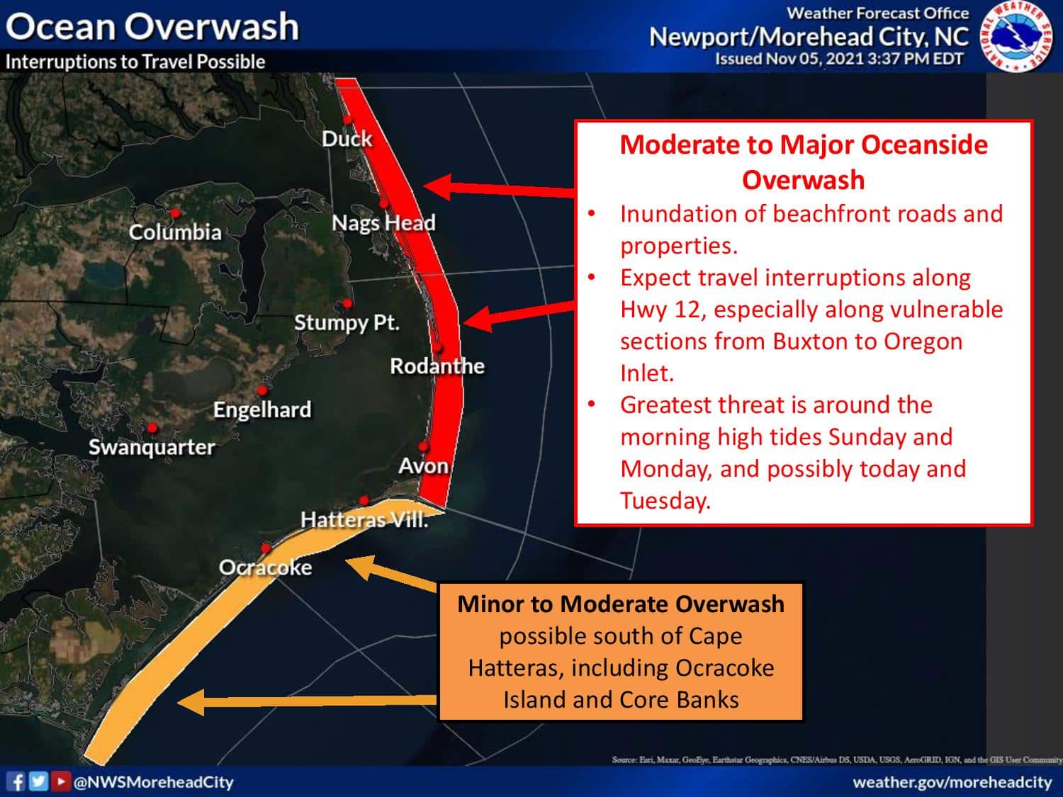
Ocean overwash is expected on portions of N.C. Highway 12, which may be impassable at times, especially on Hatteras Island during periods of high tide.
Motorists should proceed with extreme caution and check road conditions before traveling. Never drive into floodwaters.
NC 12 Update: Kitty Hawk from Basnight Bridge to Hatteras open and passable with some standing water and blown sand on road. Ocracoke: open and passable w/ blowing sand on road. For updates, follow us here or visit https://t.co/sOCjsVQDoN. #OBX pic.twitter.com/Ox9bfvNBIF
— NCDOT NC12 (@NCDOT_NC12) November 6, 2021
In Nags Head, the storm could bring ocean overwash to South Old Oregon Inlet Road and sections of South Virginia Dare Trail.
“Do not drive through the flooded areas, there could be debris in the water. Should you wish to park your vehicle on higher ground, feel free to park at Town Park at 415 W. Health Center Dr. (turn west at Ace Hardware),” according to a post on the Town of Nags Head website.
Due to the expected high winds, all Nags Head residential sanitation collection will occur on Tuesday and Friday next week. Do notroll any carts to the street until Monday evening.
If you are in the Sector Two bulk item/brush collection area, please do not place your items for collection by the road until Monday night.
Live view from NCDOT camera at Mirlo Beach:

“N.C. Department of Transportation officials on Friday used heavy equipment to push sand onto dunes from Pea Island to Ocracoke and then staged graders, excavators and other equipment along potential trouble spots to respond in case conditions worsen through the weekend,” said NCDOT spokesperson Jamie Kritzer.
“Digital message boards along N.C. 12 were updated Friday to alert travelers of possible dangerous driving conditions,” Kritzer said.
“Before traveling on the Outer Banks or in low-lying coastal areas this weekend, people are urged to check the current driving conditions at DriveNC.gov and stay tuned to NCDOT on social media,” Kritzer said.
Ferry departures for the Ocracoke-Swan Quarter and Ocracoke-Cedar Island routes have been canceled Saturday, due to high winds that have made travel unsafe across the Pamlico Sound. Sustained winds of 35 mph were recorded by ferry crews this morning.
The following departures have been cancelled:
- Ocracoke-Swan Quarter: 10 a.m., 1:30 p.m., 4:30 p.m., 6:30 p.m.
- Ocracoke-Cedar Island: 4 p.m., 4:30 p.m.
The Hatteras-Ocracoke ferry routes are on schedule. However, that ferry and other routes could be canceled later today, due to the strong coastal storm forecast this weekend.
Travel along the four-wheel drive area north of Corolla to Swan Beach and Carova will be difficult-to-impossible at times due to waves breaking up to the dunes.
The National Park Service said Cape Hatteras National Seashore off-road vehicle routes will likely be impassable for the next several days. All Seashore users should stay out of the Atlantic Ocean until conditions subside.
“Visitors should take this storm seriously as it could be one of the strongest storms of the season,” stated David Hallac, superintendent, National Parks of Eastern North Carolina. “If possible, visitors should avoid travel to Seashore destinations until after the storm leaves the area.”
Kill Devil Hills and Nags Head have closd their beaches to off-road vehicle access through the duration of the storm.
According to the National Weather Service office at Newport/Morehead City, impacts expected from the system include:
- Ocean Overwash: Moderate to major north of Cape Hatteras, minor to moderate Cape Hatteras to Cape Lookout. Portions of N.C. 12 and some beachfront properties likely inundated at times, especially around the time of the morning high tides.
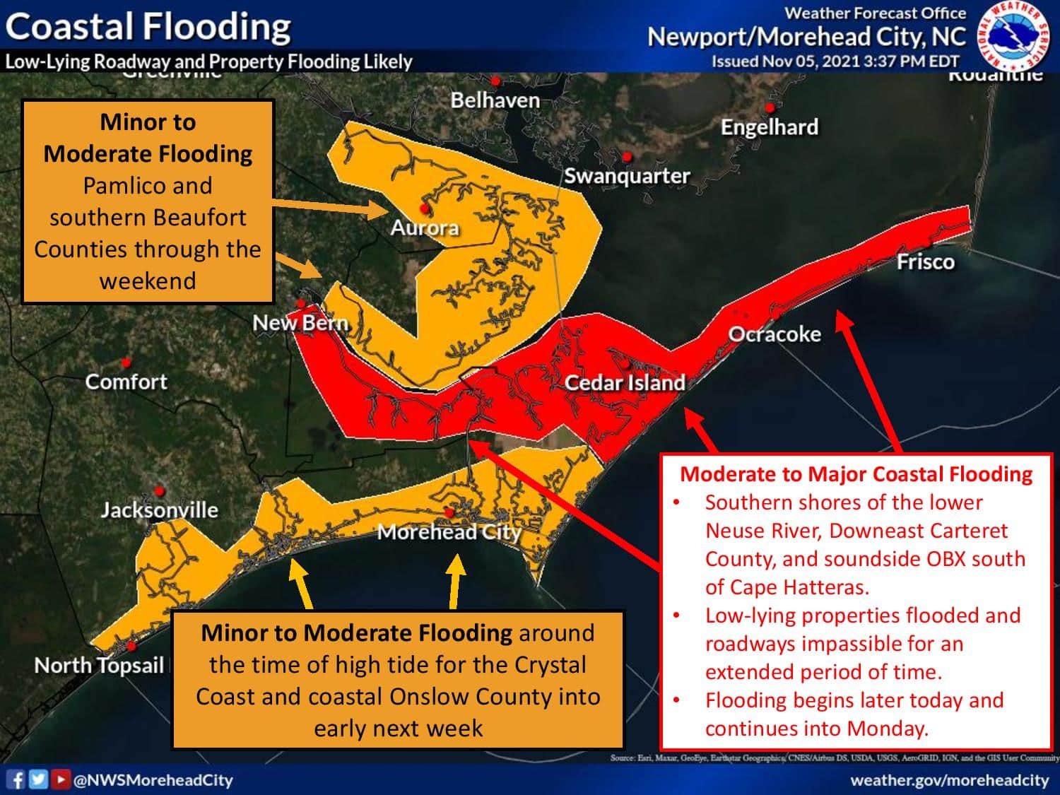
- Coastal Flooding: Moderate to Major adjacent to the southern Pamlico Sound, minor to moderate along the coast south of Cape Lookout. Low-lying roads and properties flooded.
- Strong Winds: Wind gusts to 45 to 60 mph along the coast could bring scattered power outages. Strongest winds Downeast Carteret through the Outer Banks.
- Heavy Rainfall: Rainfall totals 2-4 inches along immediate coast could bring localized nuisance flooding and exacerbate coastal flooding issues.
- Very Dangerous Marine Conditions: Seas 15-20 ft and strong Gale to Storm Force winds. Powerful surf and minor erosion at the beaches.
A coastal flood warning is in effect until Tuesday 1 a.m., a high surf advisory from Saturday 8 a.m. until Tuesday 7 a.m., and a high wind warning has been issued from 2 p.m. Saturday to 11 p.m. Sunday.
Ocean overwash will be most likely with high tide Sunday around 9 a.m. and 10 p.m. and lasting for several hours afterwards. Monday, high tide is around 10 a.m. and 11 p.m.


National Weather Service weather forecast for Nags Head, as of Saturday 7 p.m.: