

UPDATED, Monday 8:15 p.m.
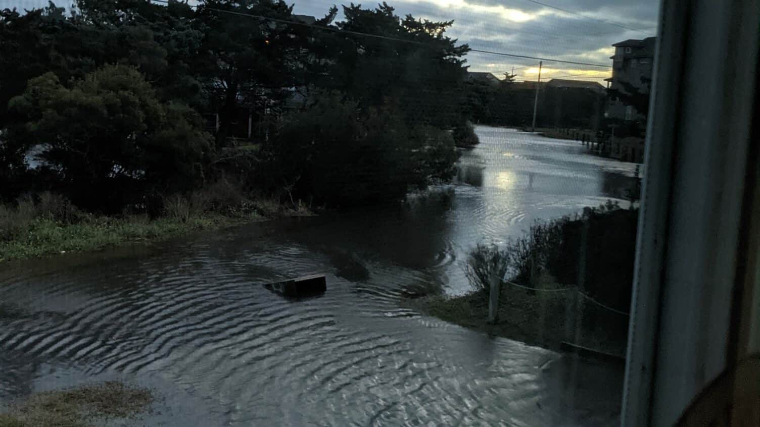
Winds continue to blow out of the west between 20 and 30 mph, with gusts of 40 to 45, and there are still areas soundside where the water has remained up or risen again with tonight’s lunar high tide.
Winds are forecast to gradually decrease during the overnight hours and that will allow the water to drop again.
According to the latest reports from the Dare County Sheriff’s Office, on Colington Road there was standing water in the westbound lane near The Blue Crab, and both lanes between Billy’s Seafood and The Saltbox.
Along N.C. 12 on Hatteras Island, some standing water will be found in low spots between Oregon Inlet and Salvo. Avon to Frisco is clear.
There is a small amount of sand and water entering Hatteras village in the area of Austin Road, and a small patch of standing water near Eagle Pass.
With high tide between 8 a.m. and 10 p.m., water levels may increase slightly, mainly in areas prone to flooding from west winds. NCDOT reports no ocean overwash this evening.
All roads remain open at this time, but travelers are advised to use caution.
Downtown Manteo:
National Weather Service forecast for Nags Head, as of 8 p.m.:
PREVIOUS COVERAGE FROM THROUGHOUT THE WEEKEND:
UPDATED, Monday 8:15 a.m.
UPDATED, Monday 7:45 a.m.
Strong southwest winds will continue today, leading to soundside flooding in normal trouble spots from Duck to Avon, as well as along the mainland.

Conditions along the roadway per the NCDOT:
Oregon Inlet to Mirlo Beach: Some blown sand and standing water from heavy rain last night. Passable
Rodanthe-Waves-Salvo: Soundside flooding with 6-10 inches of water on road. Passable with extreme caution.
Buxton to Hatteras: Blown sand and some standing rainwater. Passable.
Ocracoke: Some ocean overwash and sand. Passable.
Good morning! Winds remain too strong to operate at Hatteras, Pamlico Sound and Pamlico River. Meanwhile, the Cherry Branch route has resumed a limited schedule and Currituck-Knotts Island is back in service. pic.twitter.com/jT88uquU0A
— NCDOT Ferry Division (@NCDOT_Ferry) January 17, 2022
UPDATED, Sunday 9 p.m.
Winds are shifting to an offshore direction now, and that is expected to push the sounds back towards the Outer Banks tonight into Monday.
PLEASE RT: Rapid water level rises possible late tonight into Monday as winds shift west-southwest. Inundation of 2 to 4 feet above ground level are expected for sound side portions of the Outer Banks, especially north of Hatteras. #obxwx #ncwx pic.twitter.com/4HihXcW3na
— NWS Newport/Morehead (@NWSMoreheadCity) January 17, 2022
UPDATED, Sunday 8 p.m.
Update from the N.C. Department of Transportation posted at 7:30 p.m.:
There is currently strong wind and heavy rain at many locations on Hatteras Island. N.C. 12 is open, but travel tonight is treacherous. Don’t go out unless you absolutely have to. Here’s some location-specific conditions:
- Oregon Inlet to Pea Island Visitor Center: no overwash, many areas of standing water and blown sand. Roadway is passable.
- Mirlo Beach: Some minor trickle overwash, roadway passable.
- Buxton: Minor overwash, roadway passable.
- Hatteras: Some blown sand on roadway, standing rainwater at several locations. Roadway passable.
- Ocracoke: Moderate ocean overwash, sand on roadway. Roadway passable.
Crews were going to remain out until about 7:30 p.m. clearing what sand has blown or washed on N.C. 12, and then return in the morning before the 7 a.m. high tide.
From the Dare County Sheriff’s Office at 7:30 p.m.:
Colington Road is passable with some puddles. The S Curves in Rodanthe are still passable with sand on the road, DOT is on scene. Galleon Dr in Salvo is passable with spots of heavy water and sand. Ramp 38 North bound lane has 2 inches of rain water but still passable. Sand and ocean tide are in the roadway at the Cape Hatteras Motel. Ocean overwash is in the North bound lane of Corbina Dr and NC 12 in Rodanthe.
National Weather Service forecast for Nags Head, as of Sunday 8 p.m.:
Mostly sunny, with a high near 41.
UPDATED, Sunday 2:50 p.m.
While the large winter storm crossing North Carolina has brought snow, sleet and freezing rain to interior sections of the state, it’s just been a typical chilly, raw Sunday in January on the Outer Banks.
Heavy rain, strong winds, and coastal flooding are likely tonight through Monday, according forecasters at the Newport/Morehead City National Weather Service office.
Rain has increased in coverage through the day, as have the winds. Ferry service has been the only travel impacts so far along the coast.
Ferry update. 👇 https://t.co/xyzDsa1kbK
— NCDOT (@NCDOT) January 16, 2022
Strong southeast winds on Sunday will shift to the west and southwest Sunday night into Monday, resulting in minor to moderate water level rises. In addition, large waves will likely lead to ocean overwash and beach erosion.
There is also a threat of strong to severe thunderstorms, with heavy downpours and even an isolated tornado possible, mainly late Sunday afternoon and into the evening.
1/16/22 morning #ncwx update:
• There have been very little changes in expected impacts from a strong winter storm currently moving through the region. Precipitation will end from south to north Sunday evening, leaving cold temperatures behind into Monday. pic.twitter.com/8WxnlipnHK— NC Emergency Management (@NCEmergency) January 16, 2022
1/16/22 – 730AM: Strong gusty winds and heavy rain may combine to bring down some trees with scattered power outages later today into early evening, especially near the coast. pic.twitter.com/ZguIOrov9w
— NWS Newport/Morehead (@NWSMoreheadCity) January 16, 2022
A High Wind Warning will go into effect Sunday at 4 p.m. along Hatteras and Ocracoke islands Wind gusts of over 50 mph are expected Sunday evening as the center of the storm system passes to our west. A Wind Advisory will also be in effect for the northern beaches and inland counties in northeast N.C.
A High Surf Advisory starts Sunday at 1 p.m. for large breaking waves in the surf zone of 6 to 12 feet. A Coastal Flood Warning begins Sunday at 4 p.m., with the possibility of flooding of 2 to 4 feet above ground level along beaches and soundside.
The weather service says to be alert for rapid water levels rises along the soundside of the Outer Banks late Sunday night and Monday as winds shift from onshore to offshore after midnight.
Some sections of eastern North Carolina away from the water have seen a brief period of a wintry mix, with freezing rain, sleet and light snow this morning.
A Winter Weather Advisory was in effect this morning for Washington, Beaufort, Bertie and Hertford counties and points west.
The storm is bringing mainly wintry weather conditions west of I-95 in North Carolina, with freezing rain in the central sections of the state and heavy snow in the foothills and mountains.
Stay with the OBX Today Weather Center, Beach 104, Big 94.5 WCMS, 99.1 The Sound and Z 92.3 for all the latest info.
National Weather Service forecast for Nags Head, as of Sunday 9 a.m.: