

UPDATED, 9:30 p.m.: The last squall line of heavy rain and wind has crossed the Outer Banks over the last hour, but for the most part Tropical Storm Elsa has not caused any serious issues along the beaches or soundside.
A few scattered power outages have been reported in the area, with around 150 customers in the dark in Dare and Currituck counties combined.
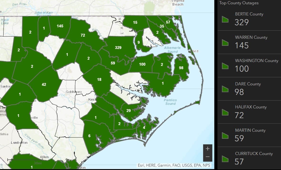
On the mainland, some minor roof damage along with a few downed trees and power lines has been reported in southern Camden County.
Sustained winds of 46 mph were recorded on the Pamlico Sound Thursday night, while the highest wind gust was at Kitty Hawk Kites Resort in Waves of 63 mph at 9:58 p.m.
The earlier tornado watch has been cancelled. A high risk of rip currents is forecast on Friday for the south facing beaches of Frisco, Hatteras and Ocracoke, with a moderate risk from Corolla to Buxton.
UPDATED, 4:30 p.m.: Hyde County Emergency Management reported a tornado on the ground in the White Tail Farms neighborhood of Fairfield at 3:14 p.m. There have been no damage reports so far.
Several tornado warnings have been issued for Hyde, Tyrrell and Washington counties in the past hour.
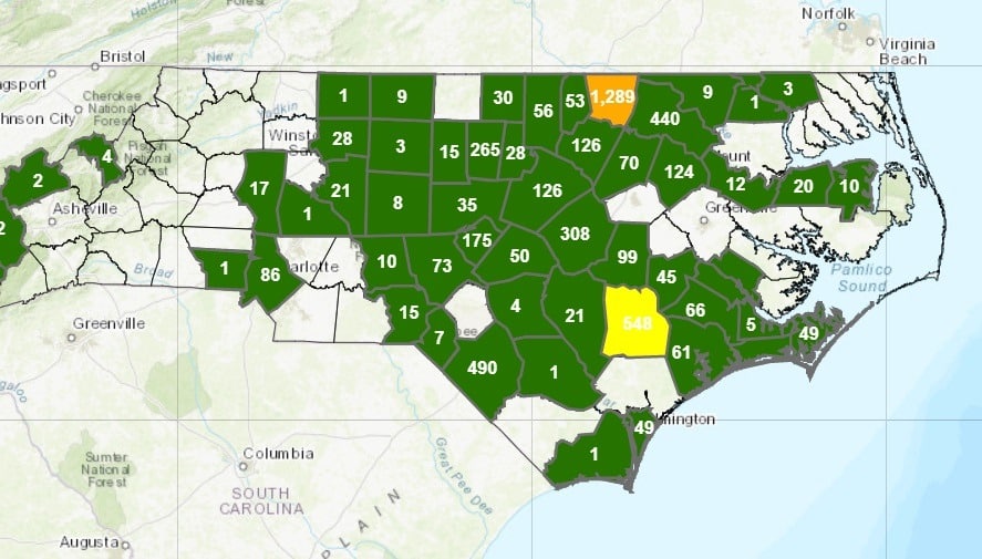
Just widely scattered power outages have been reported so far, with the largest numbers in Warren and Duplin counties as of 4:30 p.m. Around 1,100 customers lost power in Brunswick County this morning.
EARLIER STORY: The National Weather Service has extended the tornado watch for the Outer Banks through 11 p.m. as Tropical Storm Elsa moves through eastern North Carolina.
Elsa is expected to bring locally heavy rainfall with a couple isolated tornadoes possible. A tornado WATCH means tornadoes have the potential to form over the next few hours.
Here’s what you need to do right now:
- Stay tuned to local media for the latest updates
- Make sure you have multiple ways to receive watches and warnings today
- Know where to go for shelter if you receive a tornado warning
Heavy rainfall of up to three inches with localized flash flooding, isolated tornadoes, gusty winds up to tropical storm strength, as well as high surf and dangerous rip currents should be expected.
Dare County Emergency Management urges residents and visitors are encouraged to stay abreast of changing weather conditions and to be ready to take action to protect themselves and their property. Protective actions may include avoiding travel during periods of heavy rain and high winds, not driving through flood waters or parking vehicles in areas that could flood. Stay informed of hazardous weather conditions by enabling government alerts and keeping mobile devices turned on to ensure receipt of National Weather Service alerts.
For up-to-date weather information, visit the National Weather Service at Newport/Morehead City at www.weather.gov/mhx. For updated information regarding road conditions on N.C. Highway 12, follow the North Carolina Department of Transportation on Facebook at www.facebook/ncdot, on Twitter @NCDOTNC12 or visit drivenc.gov.
In addition to ensuring mobile devices have government alerts enabled, Dare County Emergency Management encourages residents and visitors to sign up to receive emergency alerts—including severe weather watches and warnings, public safety and emergency-related warnings, and other time-critical notifications—by visiting www.OBXAlerts.com. Those that sign up can choose delivery methods to include email, phone call and text messages. For those that only want to receive alerts from Dare County Emergency Management as text messages, you can opt-in by texting DareEmergencyAlerts to 77295.
For more information on preparedness actions you can take to protect yourself and your property during storms this hurricane season, visit www.DareNC.com/Hurricanes.
Elsa became a tropical storm on July 1, the earliest ever for the fifth named tropical cyclone of the year to form in the Atlantic, breaking the record set in 2020 by Eduardo. It has since reached hurricane status twice, most recently Tuesday night as it moved past Tampa Bay.