Radar image of Bertha on May 27, 2020. [NWS Charleston, SC]
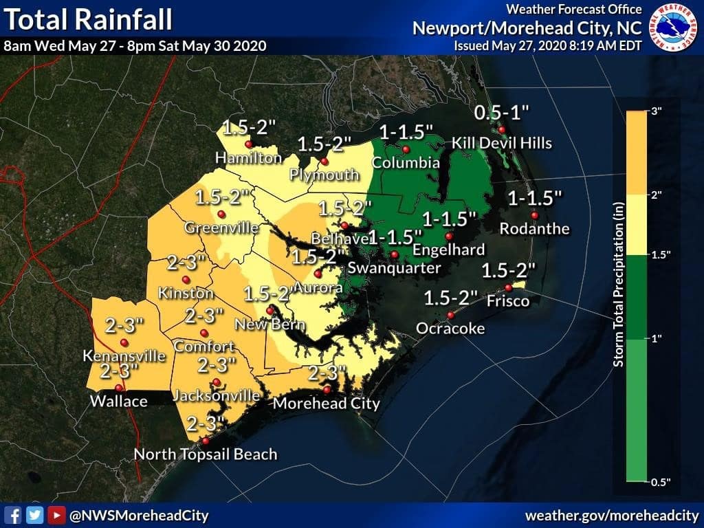
An area of low pressure off the southeast U.S. became the second tropical storm of 2020, and is expected to bring eastern North Carolina another steady dose of rain lasting into the weekend.
Just minutes after issuing a special tropical weather outlook, the National Hurricane Center put out the first advisory for Tropical Storm Bertha at 8:30 a.m.
At 9:30 a.m., Bertha made landfall 20 miles east of Charleston, S.C., with maximum sustained winds of 50 mph.
Forecasters expect the storm to weaken to a tropical depression after moving inland and become a remnant low tonight as it moves into central North Carolina.
It is only the fifth time there have been multiple preseason storms, which also happened in 1887, 1908, 2012 and 2016. This is also the sixth straight year at least one tropical system has been named before the beginning of the hurricane season.
Heavy rainfall from the system could cause flash flooding over portions of the Carolinas through Saturday.
A moderate risk of rip currents is posted for Wednesday along all Outer Banks beaches and more low clouds and fog are forecast for northeastern N.C. before the rain moves in, thanks to a continued onshore flow.
National Weather Service forecast for Nags Head, as of Wednesday 8 a.m.:
Today
A chance of showers after 8am. Areas of fog before 2pm. Otherwise, mostly cloudy, with a high near 78. East wind 8 to 15 mph, with gusts as high as 21 mph. Chance of precipitation is 50%. New precipitation amounts of less than a tenth of an inch possible.
Tonight
A chance of showers, then showers likely and possibly a thunderstorm after 2am. Cloudy, with a low around 68. Southeast wind 13 to 15 mph, with gusts as high as 21 mph. Chance of precipitation is 60%. New rainfall amounts of less than a tenth of an inch, except higher amounts possible in thunderstorms.
Thursday
Showers likely and possibly a thunderstorm before 8am, then showers and thunderstorms likely after 8am. Mostly cloudy, with a high near 77. South wind around 14 mph, with gusts as high as 20 mph. Chance of precipitation is 60%. New rainfall amounts between a tenth and quarter of an inch, except higher amounts possible in thunderstorms.
Thursday Night
A chance of showers and thunderstorms. Mostly cloudy, with a low around 69. South wind 13 to 15 mph, with gusts as high as 20 mph. Chance of precipitation is 50%. New rainfall amounts of less than a tenth of an inch, except higher amounts possible in thunderstorms.
Friday
A chance of showers and thunderstorms. Partly sunny, with a high near 78. South wind 10 to 16 mph, with gusts as high as 21 mph. Chance of precipitation is 50%. New rainfall amounts of less than a tenth of an inch, except higher amounts possible in thunderstorms.
Friday Night
Showers likely and possibly a thunderstorm. Mostly cloudy, with a low around 68. Chance of precipitation is 60%. New rainfall amounts between a tenth and quarter of an inch, except higher amounts possible in thunderstorms.
Saturday
Showers and thunderstorms likely. Mostly cloudy, with a high near 78. Chance of precipitation is 70%.
Saturday Night
Showers and thunderstorms likely. Mostly cloudy, with a low around 64. Chance of precipitation is 60%.
Sunday
Mostly sunny, with a high near 73.
Sunday Night
Partly cloudy, with a low around 59.
Monday
Sunny, with a high near 68. Breezy.
Monday Night
Mostly clear, with a low around 59.
Tuesday
Sunny, with a high near 70.
Subscribe to our Daily Email Newsletter!
Get the top stories from the Outer Banks in your inbox each morning.