

By Jennifer Allen, Coastal Review
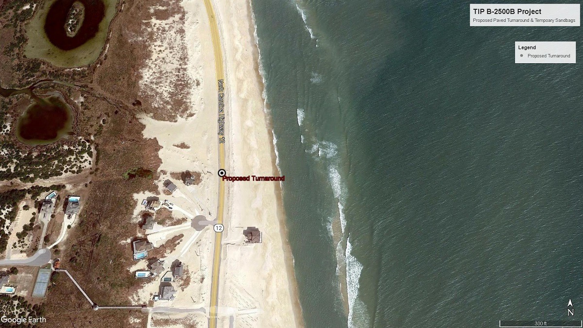
The Coastal Resources Commission has given the state Department of Transportation approval to build a turnaround area for traffic where the existing part of N.C. 12 will come to a dead end after the Rodanthe “jug-handle” bridge opens to vehicles, and to protect the turnaround from erosion, it is allowing construction of an unusual sandbag wall.
During its meeting Thursday in Beaufort, the commission granted the department a variance from state coastal management rules that prohibit the construction as planned.
The Rodanthe bridge, which is expected to open to traffic next month, bypasses the vulnerable section of N.C. 12 often called the “S-curves” or the “Rodanthe hot spot.”
The Rodanthe bridge, which is expected to open to traffic next month, bypasses the vulnerable section of N.C. 12 often called the “S-curves” or the “Rodanthe hot spot.”
Once the jug handle-shaped span is complete — it extends over the Pamlico Sound from the southern end of the Pea Island National Wildlife Refuge and ties back into the existing highway at Rodanthe — NCDOT plans to relocate the N.C. 12 designation to the bridge and remove the existing roadway and the temporary sandbags that now run parallel to the highway through the refuge.
Last fall, NCDOT applied to modify the Coastal Area Management Area major permit for the project. The permit had only authorized NCDOT to build a paved driveway south of the refuge on existing N.C. 12, but not a turnaround area. The Division of Coastal Management denied NCDOT’s application because the proposed work is inconsistent with the commission’s oceanfront setback and sandbag rules. NCDOT then applied for the variance.
“Due to its location, DOT believes the Turnaround Site would be exposed to similar erosion, overwash, or other severe weather and tidal events typically experienced in the Rodanthe Hot Spot without protection from the proposed temporary sandbag structure on the north end of the Turnaround Site, running perpendicular to the existing sandbags running along existing NC 12,” according to the variance request.
NCDOT Communications Officer Tim Hass with Division 1, which includes the Outer Banks, described for Coastal Review Friday the process ahead, now that the department has the approval it had sought.
“After the Rodanthe jug-handle bridge opens to traffic, the turnaround will be installed on old N.C. 12 to allow traffic to reverse direction where the road will dead end just south of the boundary of Pea Island National Wildlife Refuge. NCDOT will remove approximately 1.8 miles of pavement from the refuge in the area bypassed by the jug-handle bridge. NCDOT will install sandbags and a dune to protect the turnaround,” Hass explained.
North Carolina Department of Environmental Quality Assistant General Counsel Christine A. Goebel explained to the commission Thursday that beach erosion, dune loss and damage to N.C. 12 have been particularly severe in the Rodanthe S-curves hot spot. The hot spot, which includes the southern end of the refuge, is characterized by low-lying land that transitions from sound shoreline and marsh to a flat beach and the ocean all within a few hundred feet.
“The Rodanthe hot spot is susceptible to shoreline erosion, overwash, coastal flooding, the loss of beach and dunes and sand cover. These circumstances can undermine the integrity of the road, making travel by the general public unsafe and forcing NCDOT to close the road,” she said.
Goebel also refreshed the commission on the work leading up to the request. In 2002, NCDOT and the Federal Highway Administration, or FHWA, along with other state and federal agencies, expanded the scope of an environmental study that originally started out as the “NC 12 Replacement of Herbert C. Bonner Bridge.” The expanded study looked at N.C. 12 from the southern end of Bodie Island across the Oregon Inlet and through the refuge to Rodanthe, or about 14 miles, including the S-curves.
In December 2010, FHWA announced plans for the N.C. 12 replacement of Herbert C. Bonner Bridge, and approved construction of the first phase of the project.
Goebel said that the Division of Coastal Management on Sept. 19, 2012, issued a Coastal Area Management Act major permit authorizing NCDOT to build the Bonner Bridge replacement. That work was completed in February 2019, when the 2.8-mile Marc Basnight Bridge, which spans Oregon Inlet, opened to traffic.
When the permit was issued in 2012, the final design was not complete for the next phases of the project. As a result, the CAMA major permit has been modified numerous times since to authorize subsequent phases of the project and related changes.
NCDOT was able to award a contract for design and construction of the jug-handle bridge in 2016, when the document recording proposed N.C. 12 improvements was issued. The document includes plans to remove 1.8 miles of N.C. 12 in the refuge and maintain the existing secondary state road for the turnaround. NCDOT also said it would transfer 19.27 acres of existing N.C. 12 easement back to the refuge to be restored to a natural state.
In September, NCDOT filed a request to modify the CAMA permit to build the paved turnaround and install the temporary sandbag structures on existing N.C. 12 south of the refuge boundary to protect the turnaround, Goebel said.
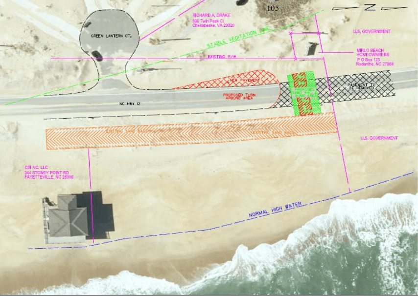
NCDOT proposed installing about 1,400 square feet of new asphalt on the landward side of the existing roadway to provide a safe turnaround for traffic within NCDOT’s existing right of way. NCDOT also proposed installing a temporary sandbag structure across the removed roadway bed, perpendicular to the shoreline, to protect the turnaround from erosion damage.
The temporary sandbags are white, trapezoidal-shaped and made of woven polypropylene and are to be placed in two adjoining rows perpendicular to the shoreline at the end of where existing N.C. 12 will end. One bag will be 50 feet long, 6 feet wide and 4 feet high and placed next to the turnaround. And next to it, a 50-foot-long, 8-foot-wide, 6-foot-tall sandbag will be placed, she said. Goebel reminded the commission that this type of alternative sandbag structure is like those for which the commission granted a variance in 2020 for use in Ocracoke, but that that sandbag wall was never built.
NCDOT’s permit modification request was denied by the division in a letter dated Oct. 25 because the proposed project didn’t meet the minimum 60-foot oceanfront setback and because the proposed sandbag structure would be perpendicular to the shore rather than parallel and white instead of tan, as required by commission rules. Further, the proposed size doesn’t meet allowed specifications.
NCDOT Special Deputy Attorney General Colin Justice said the existing CAMA permit included a paved driveway at the north end but did not include an area for travelers to safely turn around.
The project is expected to disturb about 6,000 square feet of land.
The narrow part of the island has some of the highest erosion rates on the North Carolina coast, Justice said, adding that the beach is flat and susceptible to overwash on both the ocean and sound sides. This resulted in numerous closures of the area in recent years.